
Mount Field
Sunlight dapples onto the paths. Ferns are abundant and calming. Moss spreads over logs and rocks.
Wildlife is invisible (I assume) despite the voluminous incidence of roadkill. We see no living creatures by or on the road as we drive 800 kilometres across our holiday.
Claire and I enjoy Russell Falls and Junnee Forest. Autumn means the falls are a trickle. These will gush and tumble in winter. The canopy is arresting and invites gratitude for this place. Wood scents exaggerate our healthiness and reinforce the idea that being in nature is therapeutic.

The early forecast suggests snow flurries and a top of six but it’s mild and fine and prettily cloudy, not Northern European gloomy.
Toadstools dot about, hiding in undergrowth. Massive fallen trees punctuate our progress and remind us that this is not a static museum but often a theatre of sudden and colossal action.
We hike inside our cocoon and the walking itself dissolves as the people and places of our conversation loom and disappear. I think this is how it should go.
I encourage Claire up the final wooden steps of our six-kilometre hike and we return to our MG hire car. MG originally stood for Morris Garages (in Oxford) but this debut experience would instead suggest that driving one is Mostly Grim.
*
On the drive home we buy strawberries.
Tahune Adventures
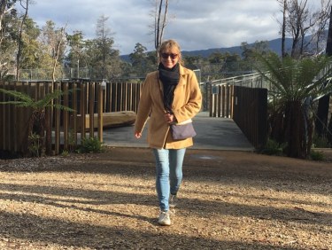
To the north of Rosehaven-lookalike, Geeveston, we tread the paths around the park and admire the Huon pine trees.
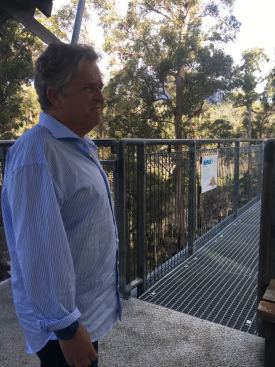
I find myself accompanying my wife along the 619 metre-length of the Airwalk. How did this happen? It’s fifty metres above the Huon River. The website suggests,
‘The full return journey takes about 50 minutes – more if you stop for photographs, spot birdlife, or pause to enjoy the clean, fresh scents of the forest.’ For you I now editorialise this: ‘Or about ten minutes if you’re rushing in terror with eyes frozen on your clumsy feet, too petrified to look out, lest you fly off the bridge to your messy doom.’
As we near completion of the elevated circuit Claire ventures onto the cantilever section. I don’t.
We see a clueless couple with a dog. The dog is also motionless with terror. I think it cruel. Dogs like being in the sky as much as the emu.
On our way around the adventure park, we talk of the pioneers and their lonely wives, the indigenous lives, the brutal and entitled English colonisation. We then talk about hot chips.

We finish with the swinging bridges and these span one hundred metres across the Huon and sixty wobbling metres over the Picton. For once I’m less scared than Claire. It’s still a height issue but I’d prefer to plummet into icy water than onto the merciless, unforgiving ground.
*
We constantly wrestle with the car radio. Hobart is home to some untreatably dreadful pop stations and Triple J is especially combative, so we go with Classic FM, and this offers the sedative strings of Vivaldi.
Cockle Creek
Meandering drive down to Australia’s southernmost point. It’s always exciting to be geographically extreme.
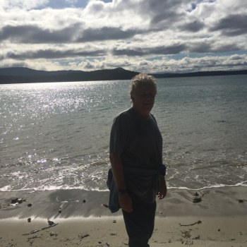
We venture past the unspoilt beaches of Recherche Bay. In Tassie, there is no hurtling along. The winding roads make driving a demanding science and not a leisurely art.
Claire visits the Cockle Creek Cemetery (happily not permanently) while I sit on a large stone and the sun washes over me.
A gaggle of loud, euphoric youth finish their week-long hike. I don’t share their exuberance and announce to Claire over our lunch that, ‘their sense of accomplishment and vitality are nauseating’. I’m not entirely joking. We munch our sandwiches.
The Fishers Point trail (trial) is two hours return, and a four-kilometre return trip, allegedly. As advised by the small sign, we, ‘consider tides and coastal conditions before undertaking this walk, as sections of beach may be restricted during high tides.’
We then read this: From the whale sculpture carpark, it’s an easy (I call bullshit) coastal walk through heathland and offers spectacular views to distant Adamsons Peak, Southern Ranges, Bruny Island, and the Southern Ocean.

Along the way cruelly camouflaged signage means we scramble over endless rocky stretches, scaring and scarring lizards and our ankles.
Throughout, the sky is a cathedral with a variety of cloud shapes and hues painting the friendly blue canvas. The beaches are decorated with driftwood and beautiful shells. Claire pockets a couple of these.
As South Australians we’re unaccustomed to trees growing right on the beach unless these are stinky mangroves. These seem to belong in the tropics and not the bottom of our world.
At Fishers Point, we explore the ruins of the 1843 pilot station and lighthouse.
A simple wooden cross at the point. Dedicated to Chris Reid. There’s also a smashed TV. Probably because the owner couldn’t watch footy on the beach due to a disappointing if predictable lack of electricity.

Claire places a rock on the cairn.
On our return the directional signage, previously hidden, is now like Vegas neon. We can see exactly how to cut through the bush and when to tramp along the sand.
*
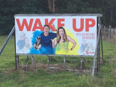
A few years’ back Triple J erected an ironic billboard just south of Dover and it’s still there. It perfectly captures the stereotype of their uni-student listenership.
To return to our Footy Almanac home page click HERE.
Our writers are independent contributors. The opinions expressed in their articles are their own. They are not the views, nor do they reflect the views, of Malarkey Publications.
Do you enjoy the Almanac concept?
And want to ensure it continues in its current form, and better? To help things keep ticking over please consider making your own contribution.
Become an Almanac (annual) member – CLICK HERE.
One-off financial contribution – CLICK HERE.
Regular financial contribution (monthly EFT) – CLICK HERE.

Now whip it into shape/
Shape it up, get straight/
Go forward, move ahead/
Try to detect it, it’s not too late/
To whip it, whip it good


Love it Mickey (and Claire).
Tahune airwalk is brilliant. As is the Geeveston bakery – which features team photos of the Huon Football Association footy team that played against the touring Collingwood side in 1939. My photo of the photo is half way down this old piece: https://www.footyalmanac.com.au/round-2-collingwood-v-richmond-an-on-it-goes/
Tahune airwalk is also important in my profession as flood forecaster – for Tahune Bridge is a forecast location for the Huon River. When the Huon floods, it floods quickly. Staff there need to retrieve anyone from the wild side of the bridge – and often then remove the removable bridge railings (to prevent those railings being beaten into random noodle patterns by racing hulks of floating, hefty Huon pine). Did you spot the flood markers?
I took this photo in June 2018.
https://www.footyalmanac.com.au/wp-content/uploads/Huon-1.png
Why the sour face? Great read Mickey.
Thanks David. Your information adds greatly to my Tuhane experience. I’m always agog when I see those previous flood level signs and these make me humble in the face of nature’s enormity. I also loved being able to witness the confluence (gee, this is a great word) of the Huon and Picton Rivers. And the idea that people had to be rescued from the wild side of the bridge! A stunning if terrifying idea.
Mickey,
Greatly enjoying your travelogue.
Thanks.
I also get the feeling that Claire is much braver than you?
Someone- I prefer contemplative.
Thanks Smokie. On bravery I suggested the synonym, ‘reckless’ to Claire and she didn’t disagree. On these outdoors matters she certainly is, but when it comes to uncorking (not really a thing anymore) the second bottle of red I probably take the honours.
While I’d love to read about a Thylacine sighting on this trip, otherwise really enjoying your Tassie travelogue and fantastic photos Mickey.
Closest I got to a Thylacine was on the label of a Cascade beer Luke! Thanks for reading. The NFA beckons.